
Principal Investigator and Contacts
Professor Peter Wadhams
University of Cambridge
Dates
February 14 – March 10, 2002
Aim of project
1. Determination of the winter 2002 hydrography of the central Greenland Sea gyre region, including the location and depth of convective events, and the structure of the Jan Mayen Current, especially where it emerges from the East Greenland Current.
2. Determination of the distribution and role of sea ice in winter processes in the region.
Funding Agency
The Commission of the European Communities, Environment and Climate Programme, as part of the CONVECTION project (2001-3)
Details
Location: 72° 57' N, 11° 27' W
Cruise plan/mission: During one dive two mission were performed under a band of drift ice which was approximately 1 x 5 nm stretching NW-SE in the Greenland Sea. The East Greenland current was flowing in a southerly direction with about one knot.
Length of mission(s): The two missions were 2 x 700m with 30m linespacing and 1000m with 50m line spacing.
Operational base: Research ship, the RV Lance
Ice type: Bands of drifting ice floes.
Water depth: <1000m
Deployment/Recovery methods: By vessel crane.
Vehicle Specifications
AUV class/type: Maridan M150
Navigation/positioning systems: Kearfott T24 INS, RDI 1200kHz DVL
Obstacle avoidance: None
Homing/guidance: None
Emergency measures: Argos Beacon, VHF Direction Finder
Parameters logged: Upward looking SideScan Sonar, Upward looking RD Instruments 600kHz ADCP, CTD, position, all time-tagged.
Communications: Wireless LAN, UHF Radio modem.
Other equipment: Sonardyne USBL
Debrief/dissemination
Publications/web sites arising from project:
Wadhams, P., Wilkinson, J.P. and Kaletzky, A., 2004. Sidescan sonar imagery of the winter marginal ice zone obtained from an AUV. Journal of Atmospheric and Oceanic Technology, 21(9), pp.1462-1470.
Details of the mission
See pages 16-17 for full details of successful runs with 2km of sidescan sonar data on 27 February 2002 with further information on page 39 onwards in the RV Lance Cruise Report.
Lessons learned for future deployments
We learnt a lot of things, especially operational issues, which most probably all could have been avoided if we had followed the guidelines in the DnV Recommended Practice “Risk management in marine and subsea operations.”
Image and the map from the RV Lance Cruise Report.
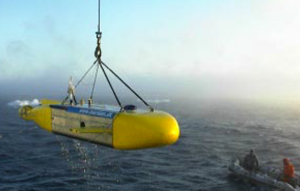
Maridan Martin 150 AUV being recovered to the RV Lance.
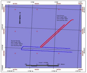
Track chart of the two runs by the Martin 150 AUV on 27 February 2002. The first survey, red track, covered 700m, with the second survey, blue track, covering 1000m. The first survey was at a depth of 20m. the second at 10m, both with a standard deviation of only 0.1m.